In Pictures - Part II
- DCHP
- Oct 25, 2021
- 7 min read

Part I of this October 2021 post ended with a few teasing questions about village photos from the archives, including this one showing houses where the village green should be. Now for some answers, starting with the Island Cottages.

The map here generously provided by Chris Jonas from the autobiographical collection of her father Peter Morgan shows how the five Island Cottages on what we know now as the Village Green were arranged. Peter himself lived with his mother and grandparents in Cottage marked "A". His father tragically died in 1925, his health having never recovered from his experiences in World War I.
The gable end of Cottage "E" is shown on the left of the photo above. In the 1920s the five cottages were home to a total of 18 people including 8 children.

Standing at the door of No. 2 Island Cottages ("A" on the map) are Peter Morgan's grandparents, Alfred and Eliza Dean. The year is 1924. Peter Morgan describes how life at the Island Cottages was "quite primitive". Lighting was by candle or oil lamp until Dorothy Morgan added a penny in the slot gas meter and a single gas lamp.

The print here from 1925 looking towards Winton House and The Old Cottage, also shows to the left the Island Cottage marked "E" on Peter Morgan's map. Right of centre is The Falcon - but notice that the steps lead from the doorway of The Falcon directly onto the street rather than to each side of the doorway from a central platform protected by railings.

The photo here shows the steps more clearly. Speculative local explanations include the possibility that the raised doorway made it easier to leap directly onto a horse but proved rather dangerous for revelling locals tottering out onto the street. The more mundane and more likely explanation is that the floor of the bar was raised above street level so as to provide easy access from the street to the cellar. Though the safety explanation for the present arrangement of the steps makes sense, the old steps no doubt represented as much of a risk to the perfectly sober visitor given the volume of traffic on Village Road in more recent times.

Another view of The Falcon and Mr. and Mrs. Carter's Island Cottage is intriguing. It shows horses with several men in uniform and riding gear and many onlookers in the background outside The Old Forge. The photograph has been dated to September 1904 and has been said to show an assembly of members of the Legion of Frontiersmen after their return from the Second Boer War in South Africa - but there is a problem.
The Legion (which is still active) was formed in Britain by Roger Pocock, a former constable with the North-West Mounted Police and Boer War veteran. Prompted by fears of an impending invasion of Britain and the Empire, the organisation was founded to be a field intelligence corps that would watch over and protect the boundaries of the Empire. However the date of its foundation was 1905, postdating the photo of the horsemen outside The Falcon. Nonetheless there are features of the image that do suggest some relationship to the story which has been attached to it.

Closing in on this image reveals another building with its own story. The low building at the centre of this image reflecting light from its roof was The Falcon's stable, but at times it served a function rather more macabre than accommodating horses. It was known as the mortuary for it was there that bodies, including those who had suffered fatal misfortune on the canal, were taken whilst the required inquests were taking place at The Swan.

As to be expected of a farming community, there was no shortage of services for horses, and Walter Baker, the Blacksmith clearly had a thriving business. He owned The Forge, his own cottage next door and five or six other adjoining cottages that he rented out, all originally 16th century constructions.

Peter Morgan's map shows how the six cottages and the forge were arranged. Notice the cottage marked G accessible only through the now widened alley and occupied in 1939 by Matt and Mrs. Clark, their two daughters and two sons. Matt was the local odd job man whose duties included emptying the primitive water closets of the Island Cottages.
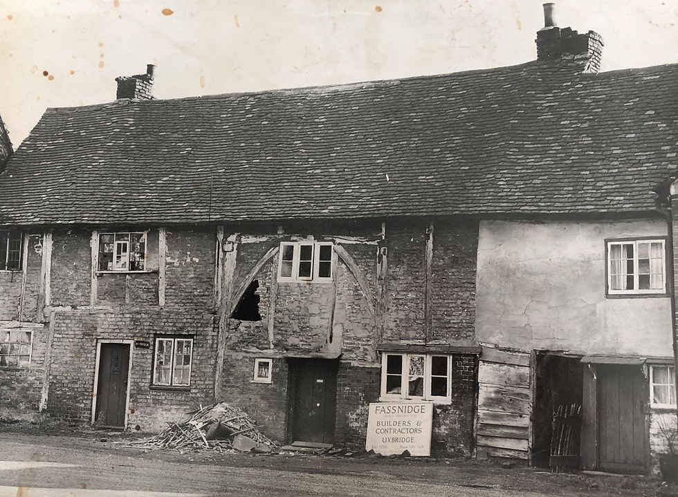
Sometime in 1932/33, Dorothy Morgan, her mother and young Peter had been moved by a new landlord out of No.2 Island Cottages. They crossed Village Road into Roadside Cottage which had the few added advantages of a small garden, with an outside toilet, an outdoor tap and a gas supply to lighting and a cooking hob. Peter recalls that the partly obscured upstairs window at the extreme left in this photo was the window of his room. In 1951 Mr. Baker's cottages were taken to pieces and restored as Blacksmiths Cottage, Forge Cottage and The Old Forge. The photo here was taken as the restoration began.


Ever enterprising, by 1936 Walter Baker had added garage services to his business and as petrol driven vehicles took over from horse drawn carriages, the forge became a petrol station. In this view captured in the 1960s, can be seen the BP pump which filled petrol tanks for the likes of David Lean, Noel Coward, Merle Oberon, David Niven, Laurence Olivier and John Mills. Though the Archer family had taken over the business, the garage itself still carried Walter Baker's name.

Here again is the garage as it appeared in the 1958 film, Stormy Crossing.

An earlier view from the 1900s, which has The Forge at its centre, also has Misbourne Cottage on the right. Perhaps one of the most iconic images of Denham village, below are just a few of many old photos of this 16th century cottage.


In 1963 both Misbourne Cottage (and the village itself) temporarily acquired a new name. It was made available as a location for the film Murder at the Gallop in which Margaret Rutherford took on the role of Agatha Christie's Miss Marple - though it was not the Miss Marple that Agatha Christie intended when she wrote her books. Her Miss Marple lived in Danemead Cottage on Old Pasture Lane in St. Mary Mead but for Murder at the Gallop, which was only loosely based on Agatha Christie's work, the film-makers moved her a fictional nine miles away from St. Mary Mead to a similar address in "Milchester".

The photo here and the earlier one below were both taken on the south side of the junction of Ashmead Lane, (formerly known as Back Lane or as Love Lane) and Cheapside Lane. It is hotly disputed amongst some longstanding village residents whether the correct historic name of this byway is Cheapside Lane or just "Cheapside". In the long ago history of the village farming community it is probably just Cheapside.

The word comes from the old Saxon "ceapan" meaning "to buy" and "Cheapside" came to mean the market place for the sale of local produce. However the keepers of the 19th century records were obviously as uncertain about the historically accurate name as we are today. In 1841 and in 1871, the byway was clearly given the name Cheapside Lane and that name has been consistently in use since 1901. However in 1851, 1861 and then again in 1881 and 1891, it was just Cheapside. Though neither side can claim total victory in this long running friendly dispute, what is clear is that Cheapside Lane (using its modern name) as the market centre has played a significant in the history of the village community.

Here we see Cheapside looking towards the junction with Back Lane. It is hard now to imagine an encounter with cows strolling down the middle of Cheapside Lane.

Closer in to the junction is the gable end of the building once the "British School", one of several such schools established in the early 19th century by non-conformist church bodies to parallel or sometimes to rival the Anglican church schools for poorer children. In front of the brick chimney is a well which seems to be on the line of an underground watercourse also tapped by a well on Old Mill Road opposite the other end of Back (Ashmead) Lane. Behind the school building was the wheelwright yard of John House. Most of the buildings in this photo have been demolished - save that is for the lighter fronted building three doors up from the school house. That is the old Methodist Chapel still on Cheapside Lane. Click here for more about the chapel.

Here is a clearer view of the chapel in its setting of dwellings most of which were occupied in the early to mid 19th century by members of the small Methodist community led by John House.

Cheapside has of course another claim to fame or infamy as it was there on 28th May 1870 that John Owens horrifically murdered blacksmith Emmanuel Marshall, his wife Charlotte and five other members of their family.
Denham's history in pictures cannot be left there with such a terrible event. Instead let us return to Village Road, to a new beginning in 1925 of an event that has been much missed these last two years. 1925 was the year that a fair returned to the village for the first time 1873 when the village "vestry" decided that it would be to the advantage of the village to abolish the medieval fair for which a licence had been granted by King Henry III to Henry de Capella as long ago as 1227.

For more about the Denham Village fair visit The fair of long ago | Denham History and All the fun of the Fayre (denhamhistory.online)
Sources
Photo collections of Ann Collins, Rob Graham and Neil Watson
Additional contributions from David Brench, Jean and Bob James and Julie Williams
A very special thanks to Chris Jonas for sharing the historically rich autobiographical recollections and photos of her father Peter Morgan
British History online - Parishes: Denham | British History Online (british-history.ac.uk)
Reel Streets - Reelstreets | Stormy Crossing (aka Black Tide) and Reelstreets | Murder at the Gallop
Wikipedia


Is there still a mulberry tree in the garden of Mull Cottage? I remember climbing the tree to pick fruit in the 1940s, when the cottage was occupied by Charles Chrighton the film director.